By Harshit | September 27, 2025 | Miami, Florida | 6:15 AM EDT
The Atlantic hurricane season escalated sharply on September 26 as Hurricane Humberto rapidly intensified into a Category 4 storm in the open ocean, gaining more than 30 mph in wind speed in just six hours. While Humberto itself is not forecast to make landfall in the United States, another storm system — currently dubbed Potential Tropical Cyclone Nine — poses a much more direct threat to the East Coast.
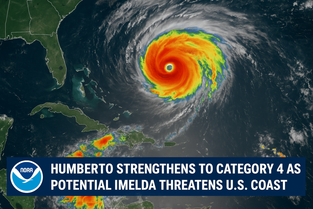
Humberto’s explosive growth
At 11 p.m., the National Hurricane Center (NHC) reported Humberto was centered about 390 miles northeast of the northern Leeward Islands, moving west at 7 mph with sustained winds of 145 mph. Forecasters expect winds to peak near 160 mph by September 27, placing Humberto firmly within the “major hurricane” category.
If projections hold, Humberto will become the third consecutive major hurricane of the 2025 season, following Erin and Gabrielle — a rare streak last seen in 1935. Though the storm is expected to track between the U.S. and Bermuda, its size and strength will produce long-period swells, raising the risk of dangerous surf and rip currents along the U.S. East Coast this weekend.
Potential Tropical Cyclone Nine: Imelda in the making
At 5 p.m. on September 26, the NHC designated a system near eastern Cuba as Potential Tropical Cyclone Nine. Located about 145 miles northwest of Cuba’s eastern tip and 145 miles south of the central Bahamas, it is forecast to strengthen into Tropical Storm Imelda within 24 hours.
The system is already showing improved organization, and watches and warnings are in place for parts of the Bahamas, where 4 to 8 inches of rain is expected. Eastern Cuba could see 8 to 12 inches, with isolated totals up to 16 inches — raising the risk of flash floods and mudslides in mountainous terrain. Hispaniola and Jamaica may also see up to 4 inches of rain.
By early next week, Imelda could intensify into a strong tropical storm or Category 1 hurricane as it tracks near the Bahamas and approaches the Southeast U.S. coast. Current models suggest a close brush with Georgia and the Carolinas around September 29–30, though significant uncertainty remains.
Flooding risks in the Southeast
Even before Imelda makes its closest approach, the U.S. Southeast faces threats from a “predecessor rain event,” where tropical moisture interacts with a cold front draped over the Appalachians. The National Weather Service said this could bring heavy rainfall to parts of the Carolinas and Virginia through the weekend.
Scott Kleebauer of the Weather Prediction Center explained that by September 28, tropical moisture linked to Imelda may start feeding into thunderstorms over the eastern Carolinas. While meteorologists stress that rainfall is not expected to reach the catastrophic levels seen during Hurricane Helene last year, forecasters warn that 6 to 10 inches of rain could still trigger flash flooding, especially in southeastern North Carolina and coastal South Carolina.
Complex interactions ahead
How Imelda and Humberto interact will be critical in determining the storm’s eventual path. One possibility is the rare Fujiwhara effect, where two storms orbit around a common center, altering each other’s tracks. Brian McNoldy of the University of Miami cautioned that Humberto’s sheer strength could push Imelda away from the coast or, conversely, steer it closer depending on timing and distance.
Meteorologist Matt Lanza noted that most models currently bring the system near the Carolinas by Tuesday, but a “non-trivial” number pull it east into the open Atlantic. “Anyone having confidence in what, precisely, will happen at this point is probably not being honest with themselves,” Lanza said.
A season of rare intensity
Humberto’s rapid intensification adds to a season already marked by unusual strength. With Erin, Gabrielle, and now Humberto all reaching major hurricane status, researchers note it is the first time in nearly a century that the first three named Atlantic hurricanes have all reached Category 3 or higher.
As the weekend unfolds, residents in the Bahamas, Cuba, and the U.S. Southeast are urged to monitor official forecasts closely. While Humberto rages offshore, the looming Imelda could bring dangerous rain, flooding, and winds to millions of Americans early next week.